-
29 de mayo de 2026
Biodiversity conservation is more important than ever. At Endeavour, we are using tech innovations to improve environmental monitoring and protect natural ecosystems around our mines.
Satellite imagery and geographic information system (GIS) tools, specifically ArcGIS Pro, help us track vegetation and wildlife habitat conditions and trends around our project areas over time, and any changes that have occurred.
Through remote sensing analysis, we apply vegetation health indicators such as the Normalized Difference Vegetation Index (NDVI), which measures the density and condition of healthy vegetation, and the Normalized Burn Ratio (NBR), which helps identify areas affected by fire or vegetation loss. By comparing these values over time using the Differenced Normalized Burn Ratio (dNBR), we can detect areas of deforestation, revegetation and changes in land cover.
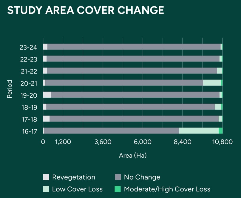
Our tracking over 2022–2024 revealed a positive development: revegetation outpaced vegetation loss and burned areas declined significantly compared to earlier years.
Key habitats such as oak forest, mixed pine-oak forest and tropical deciduous forest emerged as the most ecologically significant due to their high fauna presence.
With these findings, we have defined 2024 as our baseline year for ongoing biodiversity monitoring and management. From here, we will continue to use tech and data to track trends, guide action and strengthen conservation outcomes.